Maps and photos show massive rainfall in Florida as flooded communities face ongoing downpours
A relentless string of powerful storms soaked much of South Florida this week and Thursday's forecast predicted massive amounts of rain will continue to pummel sections of the state through Friday. Florida Gov. Ron DeSantis declared a state of emergency for Broward, Collier, Lee, Miami-Dade, and Sarasota Counties.
The National Weather Service warned that even smaller amounts of precipitation could worsen saturated areas, triggering more flash floods on Friday. Patients and workers at a cancer hospital in Fort Myers were stranded Thursday afternoon because of flooding, CBS affiliate WINK-TV reported.
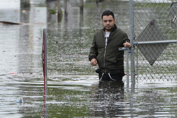
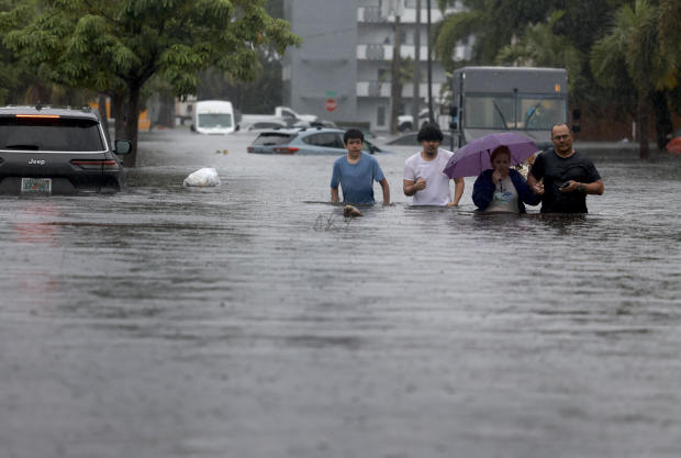
Images emerged of children traversing South Florida streets in an inflatable raft, adults wading through knee-deep water covering neighborhood blocks, and cars stalled while submerged and stranded in the middle of roadways, meteorologists warned on Thursday that as much as 8 more inches of rain could accumulate in low-lying areas before the weekend.
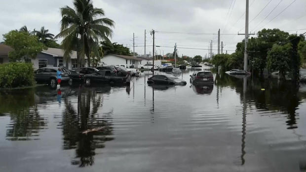
Officials said around 20 inches had fallen on Thursday afternoon in Hallandale Beach, near Fort Lauderdale. Videos from the Broward County community showed cars submerged to the hood. All Broward County schools were closed Thursday, and will remain closed Friday.
Seven million people in South Florida were under flood watches or warnings on Thursday, with forecasters projecting the most severe weather for counties previously hit by earlier deluges in the last few days.
What communities in Florida will be impacted?
A tropical disturbance triggered a rare flash flood emergency warning across the tip of the Florida peninsula Thursday. Parts of South Florida, some of which were hit hardest by heavy rains and flooding earlier in the week, were bracing for another 4 to 8 inches of rainfall through Friday, said NEXT Weather meteorologist Lissette Gonzalez on CBS News Miami.
Meteorologists at the National Weather Service updated their risk profile for excessive rainfall in Florida's southernmost areas to "high" early Thursday morning, explaining in a bulletin that the upgrade accounted "for significant impacts expected with the next round of heavy rainfall over extremely sensitive areas that include the urban corridor in Southeast FL through the I-75 corridor over Alligator Alley."
Named after the reptiles that also inhabit the land, Alligator Alley runs horizontally across the Florida peninsula from around Fort Lauderdale on the Atlantic Coast to Naples on the Gulf Coast. Florida wildlife officials have said that alligators and other wildlife could become more visible in flooded neighborhoods after a hurricane or tropical storm. It was not immediately clear whether current flooding would bring them out in the same way.
In addition to the governor's emergency declaration, Miami-Dade Mayor Daniella Levine Cava, Miami Mayor Francis Suarez and Fort Lauderdale Mayor Dean Trantalis individually issued emergency declarations for their jurisdictions in response to torrential rain and flooding.
Those declarations trigger a set of emergency management protocols that allow authorities, either at the local or state level or both, to access funds and other resources to respond to the weather. With the declaration in Miami, the city also set up distribution sites for sandbags, for residents to place outside the doors and windows of their homes to block out water, and opened nine public parking garages for people in flood-prone areas to leave their cars.
Another state of emergency was declared for the cities of Dania Beach and Sunny Isles Beach, as police and fire crews said they had conducted at least 40 rescues in Dania Beach in the midst of Wednesday's storms, CBS News Miami reported. Photos and video out of Dania Beach showed streets completely flooded, with water levels in some instances as high as a car tire.
Many of those cities and counties braced for ongoing storms throughout Thursday, and a flood warning was active for Miami-Dade and Broward Counties until 4 a.m. ET on Friday.
How much rain is Florida forecast to get?
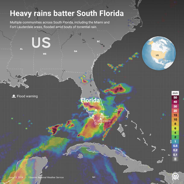
Storms have already dumped massive amounts of rain on much of southern Florida, with the latest precipitation reports indicating as much as 20 inches fell in parts of Miami-Dade and Broward Counties. These totals were just shy of the record rainfall total recorded in the state over the last three days, which surpassed 2 feet of rain in the Everglades. Along the Gulf Coast, reports show at least 6 or 7 inches fell in several counties this week, and as much as 10 or 11 inches fell in several of them.
Wednesday's rainfall set new records in a handful of places, including some as far north as Fort Myers and the Winter Haven Regional Airport, which is about halfway between Tampa Bay and Orlando, according to the weather service. In Fort Myers, the city's latest rainfall of 3.86 inches surpassed its 2008 record-high of 2.14 inches. Precipitation records for Fort Myers date back more than a century.
New rainfall totals in and around Fort Myers could potentially surpass that record, as forecasters said 2 to 4 inches of rain had already fallen in the area early Thursday afternoon and between 1 and 2 more inches was still expected.
Another heap of precipitation, potentially as much as 6 to 10 inches, could fall on parts of southwestern Florida throughout the rest of the week, they added, and the National Weather Service's Weather Prediction Center noted that even higher amounts could potentially accumulate in isolated areas along the coast and extend inland to the interior part of the peninsula. The southwestern flood watch was set to expire at 8 p.m. ET on Thursday evening.
A flood watch was in place for communities along nearly a 100-mile stretch of Florida's Gulf Coast, running from Tampa Bay through Fort Myers and extending inland for roughly the same distance at certain points in the watch area east of Sarasota. Meteorologists said that parts of coastal Sarasota County, which sits just below Tampa Bay, felt the brunt of the Gulf Coast weather on Wednesday, with 6 to 10 inches of rain recorded in various spots. One rainfall report showed almost 11.4 inches at a location in Sarasota.
A Flood Watch in effect through 8 PM Thu for parts of SW FL. Areas along coastal Sarasota County saw as much as 6-10" of rain yesterday. Parts of SW FL could see additional rain of up to 6-10" over the rest of the week. Do not drive or walk through flood waters! pic.twitter.com/ggB3OQu8X9
— NWS Tampa Bay (@NWSTampaBay) June 12, 2024
Despite the significant rainfall that already hit western Florida and the additional totals expected, forecasters said widespread flooding probably would not materialize, since precipitation would be coming in spurts and the breaks in between allowing water to drain. The primary concern was localized flooding and, potentially, flooding in urban areas. "Heavy rainfall is forecast now through the weekend. At times, this could lead to mainly minor nuisance flooding in low-lying and poor drainage areas," NWS Tampa Bay said Tuesday in a social media post.
Model derived radar imagery for the rest of tonight through Thursday indicates that more showers/t-storms are forecast with highest coverage across southwest Florida once again. Remember, if roads become flooded Turn Around Don't Drown! #flwx pic.twitter.com/GjgnoQiv2L
— NWS Tampa Bay (@NWSTampaBay) June 13, 2024
The agency advised drivers in the area to avoid flooded roads — according to National Weather Service data, almost half of all flood-related deaths in the United States each year involve vehicles.
🌧️ Heavy Rainfall Expectations 🌧️
— NWS Tampa Bay (@NWSTampaBay) June 11, 2024
Heavy rainfall is forecast now through the weekend. At times, this could lead to mainly minor nuisance flooding in low-lying and poor drainage areas. NEVER drive through floodwaters ⚠️
Here's the latest 👇 #flwx pic.twitter.com/IgbcOR8IM2
Although the Florida counties farthest south on the peninsula were expected to see the most damaging rainfall Thursday and Friday, meteorologists also warned that the proximity of certain places nearer the Gulf Coast could still face substantial threats of more heavy rain and flooding, especially in areas where the ground is already saturated from earlier storms. They said their biggest concerns for southwestern Florida could come to fruition at some point Thursday afternoon when higher overall temperatures would likely destabilize the weather systems overhead and prompt a batter of showers and thunderstorms.
- In:
- Storm
- Weather Forecast
- National Weather Service
- Miami
- Florida
- Flooding
Emily Mae Czachor is a reporter and news editor at CBSNews.com. She covers breaking news, often focusing on crime and extreme weather. Emily Mae has previously written for outlets including the Los Angeles Times, BuzzFeed and Newsweek.
Twitter InstagramDisclaimer: The copyright of this article belongs to the original author. Reposting this article is solely for the purpose of information dissemination and does not constitute any investment advice. If there is any infringement, please contact us immediately. We will make corrections or deletions as necessary. Thank you.


