Winter storm targets Northeast — here's how much snow is in the forecast
The National Weather Service issued winter storm warnings across the Northeast and New England ahead of a potential nor'easter that could dump snow on millions of people in the region Monday into Tuesday.
The weather service warned there could be heavy snow, gusty winds and moderate coastal flooding. Here's what you can expect in different areas across the Northeast:
New York City metropolitan area
At least half a foot of snow is likely for parts of New York City, the weather service said. New York City Mayor Eric Adams said the metro area could see up to 8 inches of snowfall. New York City public schools will be fully remote on Tuesday, but students will still have virtual classes.
At least half a foot of snow is also forecast for Long Island during the winter storm, weather forecasters said. Parts of interior Connecticut and the Lower Hudson Valley could see around a foot of snow from Monday night through Tuesday afternoon.
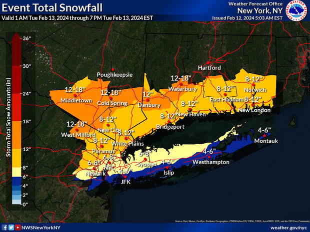
In its Monday morning briefing, the National Weather Service forecast 8 to 12 inches of heavy, wet snow in interior northeastern New Jersey, the interior Lower Hudson Valley and interior southern Connecticut from Monday night into Tuesday morning. The region could see a snowfall rate of 1 to 2 inches an hour.
The forecast also includes 15-25 mph winds, with gusts of 25-40 mph.
CBS New York forecasters have a breakdown of weather watches and warnings across counties in the tri-state area.
Boston area
Boston Mayor Michelle Wu declared that a snow emergency will start in Boston at 10 p.m. Monday. Public schools in Boston will be closed Tuesday.
The storm will be a very fast mover, with the heaviest snowfall between 9 a.m. and 3 p.m. Tuesday, CBS Boston reported. The storm will get a later start in the Cape Cod area, with the heaviest snow falling between noon and 5 p.m., according to the National Weather Service.
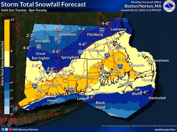
Early Monday, forecasters had expected as much as a foot of snow in some parts of the region, but the expected snow totals were later lowered.
CBS Boston forecasters expect 4 to 8 inches of snow around Boston, Worcester and the Mass Pike southward through Cape Cod and the Islands. This includes all of southeastern Massachusetts. Expect 2-4 inches from just north of the Pike up through 495, including northern Middlesex County and Essex County. No more than 2 inches of snow is expected near the Massachusetts/New Hampshire border. The best chance for more than 8 inches of snow will be from Plymouth to Providence, along with areas south to the South Coast and Upper Cape.
Snow will fall at a rate of 1 to 2 inches an hour, according to the National Weather Service. Strong winds and coastal flooding are also a concern.
Philadelphia area
The storm will start as an all-rain event for everyone in this area, even in the higher elevations of the Poconos, before snow moves in, CBS Philadelphia reported.
There's a wide range in the possible snow totals around Philadelphia. The National Weather Service predicts anywhere from minor accumulations to more than a foot of snow, depending on the location.
As of Monday morning, the weather service forecast mostly rain with minor snow accumulation of less than an inch southeast of the I-95 corridor. Heavier snow of 1 to 2 inches was forecast for the area south of the I-78 corridor to I-95, with the heaviest snow in the region forecast for I-78 northward. Forecasts in the area north of I-78 are showing 8 to 12 inches near Morristown and 12 to 18 inches near Mount Pocono.
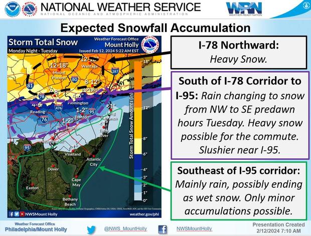
"This is a very dynamic meteorological set-up, and those dynamics will result in particularly heavy precipitation in the cold sector of this fast-moving storm, resulting in heavy snow," the NWS said. "The keys for our region continues to be how quickly the coastal low takes over and intensifies, and subsequently how quickly cold air is drawn southward late tonight through Tuesday morning, resulting in a changeover to snow from the Poconos down to the I-95 corridor."
Albany area
Heavy snow is also forecast in the Albany, New York, area. The local office of the National Weather Service said snowfall rates of 1 to 2 inches per hour or greater are expected Tuesday morning into early afternoon.
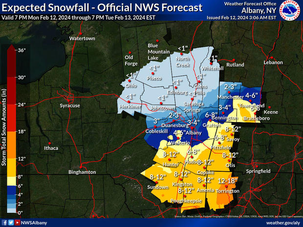
The heaviest totals are possible south of I-90. The weather service said 12 to 18 inches are possible in Torrington and 8 to 12 inches were forecast in areas around Poughkeepsie, Kingston, Sundown, Hunter and Otis.
Farther north and west, 3 to 7 inches are forecast from the Schoharie Valley to the Capital District and into much of southern Vermont. North and west of there, the forecast is for 3 inches or less.
- In:
- Weather Forecast
- Boston
- Albany
- Snow Totals
- Philadelphia
- New York
Aliza Chasan is a digital producer at 60 Minutes and CBSNews.com. She has previously written for outlets including PIX11 News, The New York Daily News, Inside Edition and DNAinfo. Aliza covers trending news, often focusing on crime and politics.
TwitterDisclaimer: The copyright of this article belongs to the original author. Reposting this article is solely for the purpose of information dissemination and does not constitute any investment advice. If there is any infringement, please contact us immediately. We will make corrections or deletions as necessary. Thank you.


