Nearly 75% of the U.S. could experience a damaging earthquake in the next 100 years, new USGS map shows
The United States Geological Survey warned that nearly 75% of the U.S. could face potentially damaging earthquakes and intense ground shaking in the next 100 years.
The agency shared new maps Wednesday, showing the areas that are most at risk. A team of more than 50 scientists and engineers created the map based on seismic studies, historical geological data and the latest data-collection technologies, according to the USGS.
They were able to identify nearly 500 additional fault lines that could produce damaging earthquakes.
In the last 200 years, 37 U.S. states have seen earthquakes exceeding magnitude 5, "highlighting a long history of seismic activity across this country," the USGS said.
Which areas are most at risk?
The USGS noted that it is not making predictions.
"No one can predict earthquakes," the agency wrote. "However, by investigating faults and past quakes, scientists can better assess the likelihood of future earthquakes and how intense their shaking might be."
The new model shows that the seismically active regions of California and Alaska are at risk of earthquakes.
The 1964 Great Alaska Earthquake and Alaska's Rat Islands Earthquake the following year were among the 10 worst worldwide since 1900, the USGS noted in 2019.
There are about 10,000 earthquakes a year in the Southern California area, though most of them are not felt. Only around 15-20 are greater than magnitude 4.0.
Hawaii also faces potential earthquakes due to recent volcanic eruptions and seismic unrest. There hasn't been a comprehensive assessment of Hawaii's earthquake risk published since 1998, and the last time one was published about Alaska was in 2007, the USGS said.
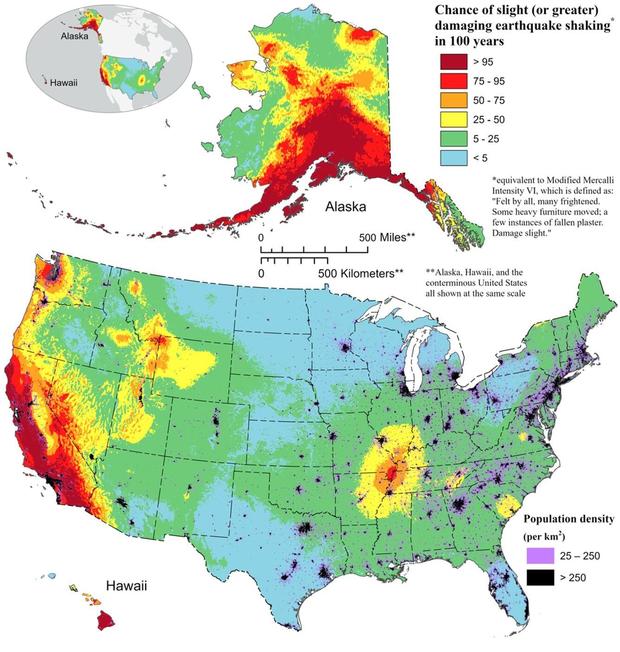
Researchers said they also found the possibility of more damaging earthquakes along the central and northeastern Atlantic Coastal corridor, including in Washington, D.C., Philadelphia, New York and Boston.
Implications of the map
USGS geophysicist Mark Petersen considers the new model "a touchstone achievement for enhancing public safety."
The USGS said the latest earthquake model could be helpful for the construction industry by providing critical information for architects and engineers. Earthquake models can also help policymakers across the country.
California, for instance, is offering $3,000 grants for earthquake retrofitting.
"In earthquakes, houses can literally fall off their foundations if the ground moves side-to-side," civil engineer Joe Demers from Alpha Structural told CBS Los Angeles. "We frequently see such failures during earthquakes."
- In:
- United States Geological Survey
- Earthquake
Aliza Chasan is a digital producer at 60 Minutes and CBSNews.com. She has previously written for outlets including PIX11 News, The New York Daily News, Inside Edition and DNAinfo. Aliza covers trending news, often focusing on crime and politics.
TwitterDisclaimer: The copyright of this article belongs to the original author. Reposting this article is solely for the purpose of information dissemination and does not constitute any investment advice. If there is any infringement, please contact us immediately. We will make corrections or deletions as necessary. Thank you.


