Tropical Storm Ophelia forms off U.S. East Coast, expected to bring heavy rain and wind
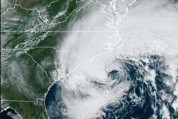
Tropical Storm Ophelia formed off the Atlantic coast early Friday afternoon and is threatening to bring heavy rain, storm surges and strong winds to the East Coast this weekend, the National Hurricane Center said.
Ophelia is moving closer to the mid-Atlantic region, with the most impact being felt in parts of North Carolina and Virginia.
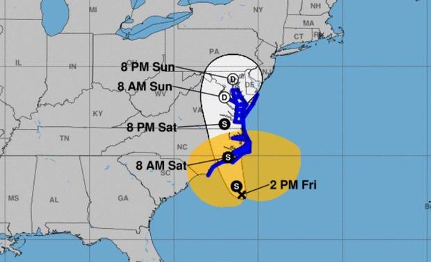
Ophelia had maximum sustained winds of 60 mph and was moving at 12 mph, according to a 2 p.m. ET advisory from the Miami-based center. The storm was centered 150 miles southeast of Cape Fear, North Carolina. It was forecast to make landfall Saturday morning.
Rain was already moving inland across North Carolina by midday Friday with some areas expected to get up to 7 inches across eastern parts of the state and into southeast Virginia, forecasters said. Storm surge warning was in effect for some areas, with surges between 3 and 5 feet forecast for parts of North Carolina, the hurricane center reported.
Schools in coastal areas of North Carolina and Virginia announced plans to dismiss students early Friday and cancel afterschool and weekend activities.
CBS affiliate WKTR reported that the storm is expected to affect North Carolina on Friday and linger until Saturday evening or Sunday morning. The rain will be heaviest between Friday night and Saturday morning, with three to six inches of rain expected while the storm is in the area. The area will be under flood watch from 2 p.m. Friday until noon Sunday, with several inches of storm surge expected. There will also be strong winds gusting up to 55 miles per hour in coastal areas.
A tropical storm warning is in effect from Cape Fear, North Carolina, to Fenwick Island, Delaware. It also includes the Chesapeake Bay south of North Beach, tidal Potomac south of Cobb Island and Albemarle and Pamlico Sounds.
North Carolina Emergency Management warned large swells from distant Hurricane Nigel also would reach the state's coast on Thursday, boosting the rip current risk. The combination of those swells and the low-pressure system could mean additional ocean overwash, beach erosion and coastal flooding.
After passing through North Carolina, the storm will travel into southeast Virginia. Virginia emergency management officials warned of heavy rain, high winds and flooding in the next few days.
On Friday afternoon, Virginia Gov. Glenn Youngkin declared a state of emergency and said the state's Emergency Support Team will be activated until the storm passes.
"As this storm has organized and strengthened, it's becoming clear based on the latest forecasts that impacts to the commonwealth are likely," said Youngkin. "We want to ensure that all communities, particularly those with the greatest anticipated impact, have the resources they need to respond and recover from the effects of this storm. Since this storm has the potential to have a range of impacts across numerous localities in the commonwealth, I encourage all Virginians and visitors to keep up with the latest forecast for their area from a trusted source, make a plan, and have their emergency kits ready."
The Virginia Department of Emergency Management said on social media Thursday that officials are coordinating with local weather service offices to watch the system developing off the coast.
Storm surge warnings are in effect from Duck, North Carolina to Chincoteague, Virginia, including Chesapeake Bay south of Windmill Point, and for the Neuse River, the Pamlico River, and portions of Pamlico Sound. Storm surge watches have been issued from Surf City in North Carolina to Duck, North Carolina, along with Chesapeake Bay north of Windmill Point to Smith Point, the Tidal Potomac south of Colonial Beach and Albemarle and the remainder of Pamlico Sound.
Meanwhile, Hurricane Nigel was downgraded to a post-tropical cyclone centered about 640 miles (1,030 kilometers) northwest of the Azores with maximum sustained winds of 70 mph (110 kph). There were no associated coastal watches or warnings as the storm moved northeast at 37 mph (59 kph), the hurricane center said in its final update on the system Friday morning.
- In:
- Weather Forecast
- North Carolina
- Virginia
Disclaimer: The copyright of this article belongs to the original author. Reposting this article is solely for the purpose of information dissemination and does not constitute any investment advice. If there is any infringement, please contact us immediately. We will make corrections or deletions as necessary. Thank you.


