Hurricane Lee's projected path and timeline: Meteorologists forecast when and where the storm will hit
Tropical Storm Lee strengthened into a hurricane Wednesday and is forecast to become an "extremely dangerous" hurricane by the weekend, forecasters at the National Hurricane Center said.
Here's what to know about the storm, where it may be headed, and when it will become a hurricane.
When did Lee become a hurricane?
The National Hurricane Center said in an update shared at 5 p.m. ET on Wednesday, Sept. 6, that Tropical Storm Lee had strengthened into a hurricane. At the time the bulletin was released, the storm was continuing to strengthen and had maximum sustained winds of about 75 miles per hour.
The storm is expected to become a "major hurricane in a couple of days," the NHC said, as the storm intensifies at a "steady to rapid" pace. It may become a Category 4 hurricane — a potentially "catastrophic" storm with sustained wind speeds of 130-156 mph — as it travels over very warm water, CBS Miami reported.
Where is Hurricane Lee heading?
The storm is moving west-northwest at about 14 miles per hour, the NHC said Wednesday afternoon. This path is expected to continue, the center said, with a "slight reduction in forward speed over the weekend."
Hurricane Lee is expected to pass near the northern Leeward Islands and Puerto Rico this weekend. The Leeward Islands are a group of islands located where the Caribbean Sea meets the western Atlantic Ocean, and include the U.S. Virgin Islands.
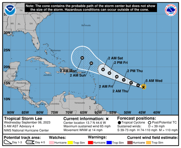
The Lesser Antilles islands may also see some impacts, with the NHC warning that the area may see some swells from the storm causing "life-threatening" surf conditions, including rip currents.
Tropical storm-force winds may impact Puerto Rico, the Dominican Republic, Haiti and the Leeward Islands over the weekend.
There are no coastal warnings or watches in effect at this time, the hurricane center said, but "interests in the Leeward Islands should monitor the progress of this system.
"The most probable scenario is that Lee will track far enough north to bring just a brush of gusty winds and showers to the northern Leeward Islands," The Weather Channel reported. But it adds, "we can't fully rule out a more southern track that takes Lee closer or directly through the islands with more serious impacts."
- How do hurricanes get their names? A look at the naming process and 2023's full list of storms
Is Hurricane Lee going to hit Florida?
Hurricane Lee is not forecast to impact the United States at this time, CBS Miami reported. CBS Miami chief meteorologist and hurricane specialist Ivan Cabrera Lee said the storm system is expected to turn to the north and away from the U.S. coast, but weather experts will continue to monitor its progress and track it closely.
Florida is currently recovering from Hurricane Idalia, which made landfall along the Gulf Coast last Wednesday and left a trail of damage across the Big Bend region — the area where the Florida peninsula meets the panhandle. The storm caused severe flooding in Florida and other states including Georgia, South Carolina and North Carolina, before moving out to sea. Several deaths have been attributed to the storm, and the financial toll of the hurricane could reach $20 billion, CBS News previously reported.
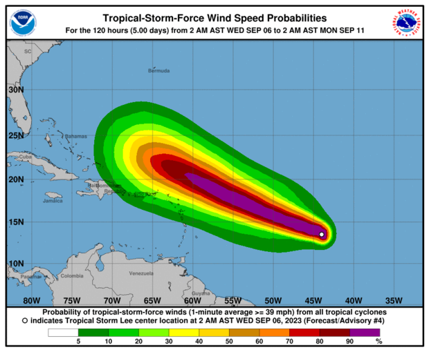
Hurricane Lee spaghetti models
Spaghetti weather models, or spaghetti plots, are computer models showing the possible paths a storm may take as it develops. These models don't predict the impact or when a storm may hit, according to the Weather Channel, but focus on showing which areas might potentially be at risk.
Spaghetti models for Hurricane Lee mostly show the storm traveling over the ocean. Some paths might take the storm close to the Leeward Islands. A recent spaghetti model for Lee created at 6 a.m. ET Wednesday shows most projected paths curving northward and remaining out over the open Atlantic, but a few veer more to the west for a potential impact in the islands or along the U.S. Mid-Atlantic or New England coast next week.
Meteorologists expect to get a clearer picture of the storm's likely path as it continues to develop in the coming days.
- In:
- Atlantic Hurricane Season
- Oceans
- Tropical Storm
- Florida
- Hurricane
- Atlantic Ocean

Kerry Breen is a news editor and reporter for CBS News. Her reporting focuses on current events, breaking news and substance use.
Disclaimer: The copyright of this article belongs to the original author. Reposting this article is solely for the purpose of information dissemination and does not constitute any investment advice. If there is any infringement, please contact us immediately. We will make corrections or deletions as necessary. Thank you.


